
There is a version of North American history that begins with Columbus, moves inland with conquistadors and fur traders, and finally resolves itself into the familiar borders of Mexico, the United States, and Canada. That version is convenient because modern countries become the containers into which everything earlier is poured. The older continent looked nothing like that. Long before Europeans arrived, materials, people, stories, religious practices, diplomatic relationships, and political power were already moving across distances that modern readers routinely underestimate.
That older connectivity is the real ground underneath many of America’s more extravagant hidden-history traditions. Egyptians, Israelites, Welsh princes, Templars, Tartars, Mormons, Masons, and lost civilizations have all been recruited at one time or another to explain something genuine: North America contained enormous cities, long-distance roads of exchange, monumental religious centers, complicated political alliances, and waterways capable of joining regions that modern national history separates. The mistake is often not recognizing the network. The mistake is assuming that Indigenous peoples could not have created it without an Old World master civilization.
The interesting history begins where evidence and mythology overlap. Cleopatra’s vanished son Alexander Helios can be followed into a modern Illinois cave legend. Mexico City really does sit beside one of the great solar monumental landscapes of the ancient world. Hernán Cortés really did describe American temples as “mosques” and houses as “Moorish.” Chocolate from Mexico really reached Chaco Canyon, Yellowstone obsidian really reached Ohio, Great Lakes copper really traveled south, and Gulf shells traveled north. Joseph Smith really looked at Midwestern mounds and called the country the “plains of the Nephites.” Europeans really called some Indigenous Americans “Tartarians.” Welsh-Mandan stories really circulated through the early republic, while later writers such as Scott Wolter and William Mann folded the Mandan, Algonquian medicine societies, Henry Sinclair, the Kensington Rune Stone, Freemasonry, and the Knights Templar into an immense pre-Columbian mystery.
What follows is therefore neither a conventional textbook history nor an attempt to declare every alternative claim true. It is an attempt to reconstruct the continent beneath the map—the documented Indigenous systems first, followed by the succession of European and American interpretations that tried to explain them.

The images above contain almost the entire problem in miniature: the bronze figure sometimes identified as Cleopatra’s son Alexander Helios; the first printed European plan of Tenochtitlan; the Pyramid of the Sun at Teotihuacan; and Pueblo Bonito at Chaco Canyon. They belong to separate civilizations separated by enormous distances and centuries of time, yet later historians and mythmakers repeatedly tried to place them inside one continuous story.
The Vanished Prince of Alexandria
Alexander Helios was real. He was one of the twins born to Cleopatra VII and Mark Antony around 40 BCE, his twin sister being Cleopatra Selene. His name was itself cosmic propaganda: Helios meant Sun, paired with Selene, Moon. Classical scholarship has long interpreted Antony’s elevation of Alexander as part of an attempt to mobilize the religious and political imagination of the eastern Mediterranean. At the Donations of Alexandria in 34 BCE, the boy was ceremonially assigned Armenia, Media, and Parthia, even though Antony did not actually control all of those territories. After Cleopatra and Antony’s defeat, Alexander was taken into Roman custody and then essentially disappears from the surviving historical record.
Even the surviving artwork traditionally connected to him carries that ambiguity. The Metropolitan Museum of Art owns a late Hellenistic bronze boy in elaborate eastern dress that has been proposed as Alexander Helios, although the museum carefully notes that the identification remains debated. The figure nevertheless captures what made Alexander so attractive to later alternative historians: he stood at the end of Ptolemaic Egypt and at the intersection of Egypt, Greece, Rome, Armenia, Persia, royal solar symbolism, and an unresolved disappearance.
That disappearance eventually became an American doorway. The controversial Burrows Cave story began in the 1980s when Russell Burrows claimed to have discovered a cave in southern Illinois containing thousands of inscribed stones and artifacts suggestive of Old World peoples. Advocates eventually developed an elaborate theory that connected some of the material to Alexander Helios and Ptolemaic refugees in ancient North America. Even people sympathetic to pre-Columbian diffusion disputed the cave almost immediately: one pro-diffusionist discussion from 1994 acknowledged that Barry Fell, Dorothy Hayden, and George Carter had already denounced the alleged site as fraudulent, while the cave’s precise location remained inaccessible and the artifacts lacked secure archaeological provenance.
The pro-Burrows literature itself reveals how unstable the story became. The Alexander Helios project’s own archived site preserves furious arguments among believers, accusations of forged pieces and fabricated cave visits, complaints about artifact sales, and the observation by one participant that many supposed Egyptian pieces looked like crude modern imitations of dynastic Egyptian art. That does not constitute archaeological evidence for a Ptolemaic colony; if anything, it illustrates how quickly an unresolved historical prince can become the organizing character of a modern American myth.
Yet the reason the story remains compelling is worth understanding. Alexander Helios turns America into a continuation of Alexandria. Once that move is made, pyramids, solar cults, mounds, sacred kingship, Masonic Egyptology, and Indigenous monumental centers can all be reinterpreted as surviving pieces of one broken imperial system.
That is not established archaeology. But the American landscape supplied unusually fertile material for the fantasy.
Mexico as the American Egypt
The easiest place to understand that attraction is the Basin of Mexico. Roughly fifty kilometers northeast of modern Mexico City stands Teotihuacan, an enormous urban and ceremonial center that flourished centuries before the Mexica founded Tenochtitlan. UNESCO describes the city as one of the most powerful cultural centers of ancient Mesoamerica, dominated by monumental architecture including the Pyramids of the Sun and Moon and the Temple of the Feathered Serpent. Its influence extended far beyond the valley.
The name “Pyramid of the Sun” itself contains an important historical layer. Mexico’s National Institute of Anthropology and History explains that the building’s original name is unknown; centuries after Teotihuacan’s abandonment, the Mexica interpreted the place through their own cosmology and associated the great structure with the Sun. The building’s westward orientation does have significant solar relationships, but the modern name is already a later interpretation of a much older sacred structure.
That distinction is useful because it mirrors what would happen again after Europeans arrived. Civilizations encountered older civilizations and interpreted what they saw through inherited sacred categories. The Mexica inherited and reinterpreted Teotihuacan. The Spanish then interpreted Mexica Mexico through categories inherited from Rome, Christianity, and centuries of confrontation with Islam.
Tenochtitlan itself was founded much later, on islands in Lake Texcoco, and by the early sixteenth century had become the capital of the Mexica imperial system. The famous 1524 map published with Cortés’s second letter presents the city as an extraordinary circular aquatic capital joined to the mainland by massive causeways. At its center sits the sacred precinct and stepped temple, surrounded by canals, roads, palaces, markets, and dense urban development. The Library of Congress notes that the image drew from both European and Indigenous sources and remains the earliest European printed image of the city.

The visual resemblance to an “American Egypt” becomes understandable here even without claiming an Egyptian origin. An immense sacred city rises from a highly engineered landscape. Monumental architecture encodes cosmic relationships, religious authority operates through an elite priesthood, agricultural surpluses support a vast capital, and political power radiates outward through tribute and trade. Those are broad structural parallels found independently in many civilizations, but to Europeans trained to search the Bible and classical antiquity for explanatory models, Mexico could appear almost impossibly familiar.
For a visual sense of why the city continues to inspire those comparisons, this recent reconstruction gives a useful—though necessarily speculative—impression of the lake, causeways, markets, and monumental center. It should be treated as visualization rather than archaeological proof of every architectural detail.

When the Spaniards Saw “Mosques”
The Spanish descriptions are one of the strongest pieces of evidence for the larger argument, because they show Europeans openly translating America through an Islamic-Iberian vocabulary. In an early letter associated with Cortés’s expedition, houses are described as having apartments “in the Moorish style,” while Indigenous sacred buildings are repeatedly called “mosques” and “prayer places.” The American Historical Association preserves the same language in its primary-source teaching collection.
Cortés continued using the terminology as he approached Tenochtitlan. His second letter calls temples “mosques or oratories,” describes priests emerging from them in ceremonial vestments, and refers to the main Tenochtitlan temple complex as the principal “mosque.” Yet the descriptions also make perfectly clear that he was not encountering Islam: Cortés describes Indigenous deities, sacrificial rites, temple offerings, and religious institutions completely unlike a Muslim mosque. “Mosque” was being used as an Iberian category for a large non-Christian sacred building.
That linguistic reflex matters. The conquistadors who entered Mexico in the early sixteenth century came from a peninsula that had only recently completed centuries of Christian-Muslim warfare and coexistence. Granada had fallen in 1492. Architectural courtyards, whitewashed walls, irrigation, urban markets, non-Christian priesthoods, and monumental sacred buildings were therefore liable to be described through a vocabulary inherited from Spain’s Islamic past.
This creates an important distinction between historical observation and historical interpretation. A Spaniard saying that Mexican houses looked “Moorish” tells us something significant about what the Spaniard thought he saw. It does not establish that Moors built Mexico. The same distinction becomes essential farther north, where Europeans began describing Indigenous Americans as Scythians, Tartars, Israelites, Welshmen, or remnants of other Old World peoples.
The tendency was persistent because America continuously exceeded European expectations. Instead of empty wilderness, Europeans found engineered causeways, irrigation, large markets, confederacies, diplomatic protocols, fortified towns, ceremonial complexes, and trade systems extending far beyond the horizon of any single expedition. Old World analogies became a way to domesticate that surprise.
The Aztec Empire Did Not Reach Utah, but the Network Did Reach North
This is where one correction actually strengthens the hidden-history argument. The political Aztec Empire did not extend from Mexico City to Utah or Missouri. The Triple Alliance’s tribute system was centered in Mesoamerica and reached through much of central and southern Mexico, but the northern Southwest and Mississippi Valley were not provinces of Tenochtitlan.
What did cross those boundaries was exchange.
At Chaco Canyon in present-day New Mexico, archaeologists have recovered scarlet macaws, parrot feathers, marine shell, and copper bells associated with southern exchange. Chemical testing of pottery from Pueblo Bonito has even identified theobromine—the chemical marker of cacao—inside vessels dating roughly to the eleventh and early twelfth centuries. Cacao cannot grow in Chaco’s desert environment; the National Park Service notes that the nearest possible source was central Mexico and explicitly describes Chaco as participating in extensive exchange with Mesoamerican peoples, including routes through Paquimé/Casas Grandes.


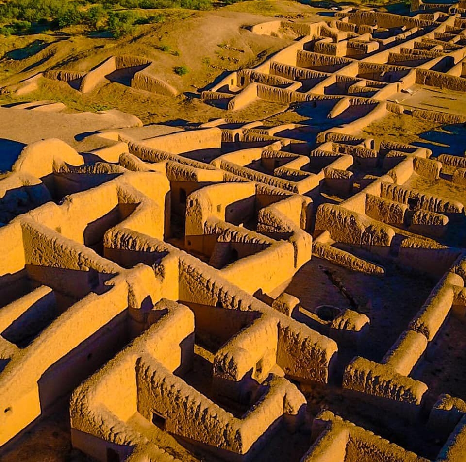
That is not a vague resemblance. It is physical evidence. Tropical cacao moved north into New Mexico, macaws moved hundreds of miles beyond their natural habitat, copper bells and marine shell entered elite or ceremonial contexts, and Paquimé became one of the major northern nodes through which Mesoamerican practices and objects interacted with Southwestern societies. The network was not an Aztec highway controlled from Tenochtitlan, but it demonstrates that the modern U.S.–Mexico border cuts directly across a much older continental exchange sphere.
The result is more interesting than a giant Aztec empire. Political borders could stop while religious objects, foodstuffs, prestige goods, artisans, stories, and travelers continued moving. What looks on a modern map like “Mexico” communicating with “the United States” was then a chain of societies whose connections did not require those categories at all.
From Chaco and Casas Grandes, the conceptual route does not end. It enters a continent already threaded by other long-distance systems.
The Roads Before the Roads
Two thousand years ago, the people archaeologists group within the Hopewell interaction sphere were moving extraordinary materials into the Ohio Valley. National Park Service archaeology documents copper from the Lake Superior region, silver from Canada, obsidian from Yellowstone, mica from the southern Appalachian region, and marine shell from the Gulf of Mexico reaching Hopewell ceremonial centers in Ohio. The Hopewell Mound Group alone contained immense quantities of nonlocal material, including the largest concentration of Yellowstone obsidian yet found east of the Mississippi.
The obsidian is particularly dramatic. Yellowstone’s Obsidian Cliff was being quarried more than eleven thousand years ago, and National Park Service research traces that stone across western Canada, the Great Lakes, and into Ohio. Roughly ninety percent of the obsidian identified in certain Hopewell mortuary contexts came from the Yellowstone source, over a thousand miles away. Archaeologists continue to debate whether particular materials moved through successive trades or through long-distance journeys and ceremonial pilgrimage, but no serious model requires Old World navigators to account for the distance. Indigenous people themselves were traversing the continent.
Caddo country supplies another piece of the continental map. The National Park Service describes trade paths radiating toward Florida, Cahokia in Illinois, Casas Grandes in the Southwest, and Rio Grande pueblos, with Gulf shells, Great Lakes copper, Appalachian mica, Ozark minerals, foodstuffs, salt, bows, and ceremonial ideas traveling through the system. That places the southern Plains and lower Mississippi world between the Southwest, the Southeast, and the great northern river basins.
Then there was Cahokia, across the Mississippi from modern St. Louis. At its height around the eleventh and twelfth centuries it was an Indigenous metropolis whose central settlement may have contained ten to twenty thousand inhabitants, with the larger urban complex supporting perhaps tens of thousands more. Monks Mound remains the largest Indigenous earthen structure north of Mexico, and the National Park Service describes Cahokia as a major political, religious, and economic center of the Mississippian world.
To nineteenth-century Americans raised on a simpler story of “primitive tribes,” these earthworks were almost impossible to accept on Indigenous terms. The result was the Mound Builder problem: if contemporary Native peoples were presumed incapable of creating monumental works, then some vanished race must have preceded them. Israelites, Phoenicians, Egyptians, Welshmen, Scandinavians, Hindus, and various imaginary white civilizations could then be inserted into the gap created by prejudice.
Modern archaeology reverses the question. The surprising fact is not that a vanished Mediterranean civilization built the mounds. The surprising fact is how extensive Indigenous networks were without one.
The Smithsonian’s short Cahokia piece is useful here because the scale of the earthworks is difficult to appreciate from photographs alone. It also shows why generations of outsiders found the site tempting material for “lost civilization” stories.
Are These Enormous Mounds Natural or Man-Made? — Smithsonian Channel
Joseph Smith Walks Into the Mound World
This is exactly the cultural environment into which Joseph Smith emerged. The Book of Mormon appeared in 1830, at a moment when Americans were already debating the identity of the mound builders, the origins of Indigenous peoples, biblical migrations, and lost civilizations throughout the interior.
During Zion’s Camp in 1834, Smith and his followers crossed Ohio, Indiana, Illinois, and Missouri through landscapes thick with ancient earthworks. The surviving accounts are unusually revealing. BYU Studies notes that Smith referred to the country through which they traveled as the “plains of the Nephites,” while participants interpreted visible mounds, bones, and ruined landscapes through the history they believed the Book of Mormon had revealed.
The famous Zelph incident followed from the same intellectual world. Members of Zion’s Camp excavated human remains from a mound in Illinois. Several later accounts attributed statements to Smith identifying the dead man as “Zelph,” a Lamanite warrior associated with an ancient conflict. The surviving versions differ substantially in detail, and even Latter-day Saint historians caution against treating the story as a precise map of Book of Mormon geography, but the essential point is well documented: Smith’s sacred American history was being overlaid directly onto the mound landscape of the Mississippi basin.
That matters for our continental story because Mormon sacred geography did not remain limited to the Midwest. Nineteenth-century Latter-day Saint thinkers also became deeply interested in the monumental ruins being publicized from Mexico and Central America. The result was a religious imagination capable of treating the Missouri–Illinois mound country and Mesoamerican urban civilization as portions of the same lost American antiquity.
In that sense, Joseph Smith belongs in the story even without requiring an actual surviving Aztec political organization stretching into Missouri. He represents a particularly influential American attempt to solve the mystery of continental connectedness by giving the mounds, Indigenous peoples, and Mesoamerican ruins a common sacred history.
The same problem was being solved differently by another popular tradition: the Welsh.
Prince Madoc and the Welsh Mandans
The Prince Madoc legend claimed that a Welsh prince sailed west in the twelfth century and reached America centuries before Columbus. By the late eighteenth century the legend underwent a major revival precisely as Anglo-American settlers were moving into the Ohio Valley. Oxford scholarship describes reports of “Welsh Indians” appearing on the expanding frontier, eventually pushing the imagined descendants of Madoc farther and farther west as settlers failed to find them where expected.
The Mandan of the Upper Missouri ultimately became the most famous candidates. Their large earth-lodge villages, agricultural economy, ceremonial traditions, and physical appearance fascinated European-American visitors. Writers seized on selected Mandan features as evidence of Welsh descent, even though no accepted linguistic, genetic, or archaeological evidence demonstrates a medieval Welsh colony giving rise to the Mandan nation.
George Catlin’s famous nineteenth-century paintings helped fix the Mandan in the American imagination. His images of organized villages with large earth lodges, ceremonies, plazas, and elaborate material culture encouraged readers to think in terms of an old settled civilization along the Missouri rather than a simple nomadic stereotype. The images themselves are invaluable records, but they also entered the same atmosphere in which observers were continually searching for European ancestors behind Native complexity.
The Welsh-Mandan idea therefore belongs beside the Mound Builder theory and Joseph Smith’s Nephite geography. All three are attempts to explain visible evidence of deep American history by attaching it to a remembered Old World people.
Then the Templars entered the story.
Sinclair, the Templars, and the Masonic America
Modern alternative-history writers have taken the older Welsh, Norse, mound, and Indigenous traditions and woven them into a much larger pre-Columbian Templar narrative. William F. Mann’s The Knights Templar in the New World argues that Henry Sinclair reached Nova Scotia before Columbus and established a Templar refuge there. His later Templar Sanctuaries in North America, with a foreword by Scott Wolter, extends the theory far into the interior, proposing alliances and intermarriage with Indigenous communities, particularly Algonquian peoples, and treating the Kensington Rune Stone and other disputed sites as markers in a hidden sacred geography. These are the authors’ claims, not archaeological consensus.
Scott Wolter makes the Masonic side explicit. His current site describes the Kensington Rune Stone as a key artifact in a theory linking the “Hooked X,” Templars, Akhenaten, and America’s founding, and promotes the view that medieval Templars reached North America before Columbus. Again, this is an alternative historical interpretation rather than an established archaeological conclusion, but it shows how completely the earlier American mystery traditions have merged with Egyptian and Masonic narratives.

The important cultural development is the merger of two maps. One map is Indigenous and archaeological: rivers, earthworks, trade materials, sacred centers, alliances, portages, and migration corridors. The second is esoteric: Egypt, Solomon’s Temple, the Templars, Sinclair, Rosicrucianism, Masonry, sacred geometry, and hidden bloodlines. Alternative historians increasingly draw the second map directly over the first.
That can create seductive coincidences because the Indigenous map was already huge. If a theory begins with the assumption that Templars moved secretly through North America, almost any preexisting trade route can become a Templar route, any ceremonial center can become a sanctuary, and any Indigenous symbol can be compared with an Old World emblem.
The real historical challenge is determining whether there is independent evidence of transmission rather than similarity. The confirmed Norse settlement at L’Anse aux Meadows demonstrates that pre-Columbian Atlantic contact is possible in principle. It does not therefore validate every Templar, Welsh, Egyptian, or Phoenician claim.
But the myths are telling us something else that is historically useful: European-Americans continually sensed that the continent possessed older pathways of power than the official colonial map acknowledged.
On that point, they were correct.
The Great Lakes Were a Political Sea
Those older pathways become especially visible around the Great Lakes. The Ojibwe, Odawa, and Potawatomi did not simply occupy adjacent territories; their traditions preserve a confederated relationship known as the Council of Three Fires. The Citizen Potawatomi Nation describes the Ojibwe as the eldest brother and keepers of medicine and faith, the Odawa as the middle brother and keepers of trade, and the Potawatomi as the younger brother and keepers of the council fire. The Odawa role included organizing hunting and commercial expeditions and maintaining extensive intertribal and later European trade connections.
That is exactly the sort of actual Indigenous hierarchy that disappears when Native history is reduced to a list of separate “tribes.” The Great Lakes functioned more like a political and commercial sea than a collection of isolated lakes. Canoe routes joined Lake Superior copper country, Green Bay, Michilimackinac, Detroit, the Illinois country, the Wabash, the St. Lawrence, and eventually the Mississippi basin.
The Miami belong within this Great Lakes–Wabash system, but one point needs to be corrected because it actually makes the waterway story clearer. The Miami people did not form a single historical territory stretching from Florida to Michigan merely because modern Florida has a city called Miami. The Miami Nation of Indiana describes Myaamionki as extending from western Ohio toward Chicago, south beyond what is now Indianapolis, and north into Michigan, with Green Bay, Detroit, the Wabash, and numerous river confluences tied together by travel and trade. The Nation even notes that Miami corn has been identified as far west as New Mexico.

That landscape makes Fort Wayne far more important than a modern regional map suggests. The portage between the Maumee system and the Wabash connected waters flowing toward Lake Erie with waters ultimately flowing to the Ohio and Mississippi. Control of such points was control of movement. Indigenous towns, French posts, British forts, and American military installations repeatedly appear in the same places because the geography had already determined their importance.
The Great Lakes therefore provide a genuine Indigenous counterpart to what later Masonic and Templar stories imagine: an organized east-west and north-south system in which ritual authority, trade, military alliance, kinship, and transportation overlapped.
No medieval knights are required to make it sophisticated.
Florida and the Southern Escape Zone
Florida developed differently. The Seminole are not simply the southern end of the Miami or Great Lakes political structure. Seminole communities emerged through a complicated eighteenth- and early nineteenth-century process involving older Florida Indigenous peoples, Muscogee/Creek migrants, Yuchi and other communities, and Africans who escaped slavery and entered Florida’s borderland society. Spain sometimes encouraged Indigenous settlement as a buffer against the expanding British colonies and later United States.
That made Spanish Florida something close to an escape frontier. Enslaved Africans could move south toward territory beyond the direct authority of their former owners, while Indigenous groups moved into spaces vacated or destabilized by earlier colonial violence. American expansion then collided with a mixed borderland whose political relationships did not conform neatly to the slave-state boundaries of the young United States. Florida’s official history explicitly notes that escaped slaves found refuge among Seminole communities and that this became one of the causes of U.S. military intervention.
George Catlin’s 1838 portrait of Osceola captures one of the most recognizable figures to emerge from that conflict. The image should not be read as generic “Indian costume”; the Smithsonian notes that Osceola’s formal clothing and metal gorgets reflected his status and that Catlin painted him while he was imprisoned following his capture.
Florida thus gives the continental story a different form. In the Great Lakes, Europeans entered powerful established commercial confederacies. In Florida, Spanish, British, African, Creek, Seminole, and American worlds collided in a shifting frontier where legal jurisdiction itself became uncertain.
That question of jurisdiction eventually reappeared in a completely different form: liquor and gaming.
The Economies Governments Could Not Easily Control
There is a long temptation to describe Indigenous border economies through the language of “crime,” especially once liquor, smuggling, reservation jurisdiction, and casinos enter the story. That framing hides the more important historical question, which is who had the authority to regulate commerce.
Alcohol provides the older example. Distilled spirits entered Indigenous exchange largely through European colonial trade. Smithsonian’s description of Peter Mancall’s major study emphasizes the movement of rum from West Indian production through colonial merchants into Native fur networks and treats the destructive liquor economy as a product of colonial commercial relationships rather than some timeless Native tendency toward alcohol.
The fur trade was likewise a jurisdictional struggle disguised as commerce. European states issued monopolies and claimed huge territories on paper, but actual inland trade depended on Indigenous transportation, diplomacy, food production, marriage relationships, and military alliance. Traders who could not maintain those relationships could not simply enforce a line drawn in London, Paris, Madrid, or later Washington.
Modern tribal gaming belongs to a much later legal world, but the same sovereignty problem reappears. The National Indian Gaming Commission traces modern tribal gaming to bingo operations established by tribes in the 1970s as sources of government revenue. After courts upheld important aspects of tribal regulatory authority, Congress passed the Indian Gaming Regulatory Act in 1988, explicitly describing tribal gaming as a means of economic development, self-sufficiency, and support for strong tribal governments while also creating regulation intended to shield gaming from organized crime and corruption.
The Seminole story is especially important because Florida tribal gaming became one of the major catalysts for the modern industry. That history should be understood alongside the much older Seminole experience of territorial autonomy and resistance to state control, rather than simply as a casino story.
The continuity is not “Native Americans have always run illicit businesses.” The continuity is that Indigenous nations have repeatedly occupied jurisdictional spaces that neighboring governments wanted to control but could not simply absorb.
That is a far more useful way to understand liquor routes, fur routes, reservation economies, and gaming.
North of the Border: A Different Imperial Arrangement
Canada preserves another version of the continental system because the Great Lakes and prairie trade networks did not stop at the future international border. Ojibwe, Cree, Assiniboine, Odawa, Potawatomi, Métis, and other peoples occupied transportation systems in which lakes and rivers mattered more than the forty-ninth parallel.
At The Forks, where the Red and Assiniboine rivers meet in present-day Winnipeg, Parks Canada describes an ancient migration and trade junction that later became central to the fur economy. Assiniboine middlemen moved European goods and Indigenous furs through the network; French traders established posts inland; and competition among the North West Company and Hudson’s Bay Company turned the region into one of the major commercial battlegrounds of the continent.
The fur companies did not create those highways. They attached themselves to them. Parks Canada describes the French-speaking voyageurs, Indigenous guides, hunters, provisioners, and Métis workers upon whom the inland trade depended. Marriages between traders and Indigenous women produced families whose descendants developed into distinct Métis communities and political institutions, especially around Red River.
The Hudson’s Bay Company eventually governed enormous territories on paper, but even at Red River its authority was limited by social reality. Parks Canada describes the settlement as almost a company town while simultaneously noting that the company had to share political power with community leaders and eventually failed to maintain its commercial monopoly against Métis insistence that they were free to trade.
This produced a northern system distinct from the American pattern. In the United States, territorial expansion increasingly took the form of treaties followed by land cessions, removal, military conquest, and state settlement. British North America more often preserved corporate trading structures and Crown treaty relationships for longer periods, although that certainly did not spare Indigenous communities from dispossession, coercive assimilation, or later state control.
The difference is institutional, not moral.
Canada’s map therefore retained the memory of an earlier continental order slightly longer: company territories, Indigenous trading nations, Métis communities, voyageurs, clan alliances, treaty partners, and immense river highways coexisted beneath the eventual provinces.
The Spanish Empire Reached the Pacific—and Then Asia
There is another connection in your original idea that turns out to be entirely real, although it belongs to the colonial period rather than an ancient Byzantine one. After conquering Mexico, New Spain became one of the crucial junctions in the first genuinely global oceanic economy.

Beginning in 1565, the Manila galleons sailed between the Philippines and Acapulco. The Smithsonian describes a 250-year exchange in which Asian luxury goods moved eastward across the Pacific while American silver moved west. The Metropolitan Museum notes that porcelain, silk, ivory, spices, and other goods arrived at Acapulco and then crossed Mexico overland, with some continuing across the Atlantic to Europe.
A detailed study of the route makes the Mexico City connection even clearer. Asian goods were unloaded at Acapulco, carried overland by muleteers to Mexico City, sold in the capital’s markets, and then redistributed throughout New Spain, toward Veracruz and Europe, or illegally south toward Peru. Merchants in Mexico City eventually exercised enormous influence over the supposedly Manila-centered system.

That means there really was a route resembling the one you were describing:
Manila → Pacific crossing → Acapulco → Mexico City → Veracruz → Atlantic world.
The important correction is chronological. This was not an ancient Byzantine-Mayan waterway rediscovered by conquistadors. It was a Spanish imperial network built after conquest, using Asian maritime knowledge, Pacific currents, American silver, Indigenous labor, colonial roads, and commercial centers that frequently occupied much older Indigenous landscapes.
But once again, the myth is attaching itself to a real structural fact. Mexico became an extraordinary east-west hinge of the world.

An object could be made in China, traded at Manila, cross the Pacific aboard a Spanish ship, move overland through Mexico, enter a merchant house in Mexico City, continue to Veracruz, cross the Atlantic, and arrive in Europe. In the opposite direction came missionaries, soldiers, silver, crops, technologies, and ideas.
For anyone already inclined toward Masonic or Hermetic models of a wisdom tradition moving Egypt → Near East → India → Southeast Asia → America, the Manila route could look like the modern survival of something infinitely older.
The documentation, however, supports a sixteenth-century imperial network rather than a prehistoric Masonic one.
Why Europeans Saw Tartars in America
The northern comparison followed a different vocabulary. An 1818 British engraving preserved by the John Carter Brown Library is literally titled “Tartarian, or Hunting Indian, Inhabiting the Inland parts of North America.” Its paired image describes an Inuit figure from Labrador. The label is genuine and belongs to a period when European writers frequently compared Indigenous Americans with peoples of northern and central Asia while debating American origins.
That should not be turned into proof of the modern internet “Tartaria” theory. “Tartar” was an enormous and imprecise European ethnographic category, often applied indiscriminately to peoples across northern Eurasia. Writers trying to explain Indigenous origins naturally compared American peoples to Siberians, Scythians, and “Tartars,” especially as geographical knowledge of the Bering region improved.
Yet it is historically revealing that European observers used different Old World mirrors at different latitudes. In Mexico the vocabulary could be Moorish, because Spaniards had recently emerged from Islamic Iberia. In northern America the vocabulary could become Tartar or Scythian, because Siberia and the Asian steppe offered an apparent bridge between the continents. Around the mounds it became Israelite, Welsh, Phoenician, or lost race. Around monumental Mexico it could become Egyptian.
The continent remained the same. The Old World analogy changed.
What the Old Observers Were Actually Seeing
The strongest version of this hidden history does not require us to choose between “everything was isolated” and “one Egyptian-Templar civilization secretly ruled America.” There is a third possibility, and the archaeological record points strongly toward it: North America contained many independent societies connected by overlapping systems of trade, pilgrimage, marriage, war, diplomacy, religion, and migration.
A person did not have to travel from Yellowstone to Ohio for Yellowstone obsidian to reach Ohio, although some people may have undertaken enormous journeys. A merchant in Tenochtitlan did not have to personally know someone at Chaco for Mesoamerican cacao or macaws to travel north through intermediary communities. A Lake Superior copper source could feed ceremonial systems hundreds of miles away. An Odawa trade expedition could connect communities whose political institutions remained independent.
The resulting continent would have looked less like a unified empire and more like an internet made of rivers, trails, portages, markets, kinship, and ritual centers.
That is why the modern borders obscure so much. The Great Lakes were not the northern edge of the United States. The Mississippi was not an American river. The Southwest was not the edge of Mexico. The Plains were not an empty barrier between civilization zones. Those categories arrived later.
Cacao at Chaco, Yellowstone obsidian in Ohio, Great Lakes copper in southern ceremonial centers, Gulf shell in the Midwest, Caddo trade routes linking Florida to Casas Grandes and Cahokia, and the Three Fires system around the Great Lakes all point toward a continent whose parts were already aware of one another in ways that older textbooks rarely conveyed.
Why the Hidden Histories Never Die
This also explains why stories of Egyptians, Templars, Welsh princes, Israelites, and lost empires never completely disappear. Each myth usually attaches itself to something real before making the speculative leap.
The Alexander Helios story attaches itself to the real disappearance of Cleopatra’s son and to controversial Illinois artifacts. The Templar theories attach themselves to real medieval maritime expansion, genuine Norse Atlantic contact, Indigenous trade networks, disputed inscriptions, and Masonic symbolism. Mormon geography attached itself to real earthworks and ruined cities. Welsh-Mandan stories attached themselves to real, sophisticated Missouri River communities that European settlers did not understand. “Tartar” theories attach themselves to genuine historic European terminology and the real Asian ancestry of much of the Indigenous population at deep prehistoric timescales.
The problem comes when analogy is treated as genealogy and network becomes empire.
A Spanish chronicler calls an Indigenous temple a mosque, so later readers infer Muslims. A European engraver calls an Indigenous hunter “Tartarian,” so modern readers infer a lost Tartarian state. A Masonic ritual resembles an Indigenous ceremony, so a Templar transmission is proposed. A pyramid faces the sun, so Egypt is inserted. A Welsh traveler hears a word that sounds vaguely Welsh, and suddenly the Mandan become Madoc’s descendants.
Those leaps are not necessary to make the underlying history astonishing.
The Hidden Continent Was Real
The deepest hidden history of North America may therefore be the one that requires the least imported civilization.
Tenochtitlan was a monumental lake capital surrounded by causeways, aqueducts, markets, temples, and tribute routes. Teotihuacan had already created a sacred solar landscape centuries earlier. Chaco participated in exchange reaching toward Mesoamerica. Casas Grandes stood between northern Mexico and the Southwest. Caddo routes connected the Southeast, Plains, Southwest, and Mississippi world. Cahokia rose beside the Mississippi as a metropolis. Hopewell ceremonial centers drew precious materials from a huge portion of the continent. Great Lakes confederacies assigned religious, commercial, and political responsibilities among related nations. Miami communities organized themselves around waterways that later became strategic American transportation corridors. Seminole Florida became an autonomous borderland involving Native, African, Spanish, British, and American worlds. Farther north, Indigenous trade networks became the foundation upon which the French, North West Company, Hudson’s Bay Company, and Métis built a new continental economy.
Then Europe arrived carrying its own sacred maps.
The Spaniards brought Granada and saw mosques. Protestants brought the Bible and saw lost Israelites. Welsh nationalists brought Madoc and found Welsh Indians. Antiquarians brought Egypt and Phoenicia and found vanished mound builders. Joseph Smith brought a new scripture and walked across the “plains of the Nephites.” Masons and occultists brought Solomon, Egypt, sacred geometry, and hidden initiation. Modern alternative historians added Henry Sinclair, Templars, the Kensington Rune Stone, Burrows Cave, and Alexander Helios.
Each generation redrew the continent in the image of the mystery it already knew.
The result is not one secret civilization waiting to be uncovered. It is more like a Russian nesting doll of continental histories: Indigenous roads beneath colonial roads, colonial trade beneath national borders, fraternal and religious myths laid over archaeology, and modern conspiracy systems laid over all of them.
That may actually be stranger than a single lost empire.
Because once the modern map is removed, America stops looking like a collection of disconnected peoples waiting for Europe to connect them. It begins to look like a continent already organized around great corridors—the Pacific coast, the Southwest, the Mississippi, the Ohio, the Wabash, the Great Lakes, the St. Lawrence, Hudson Bay, and the Red River—through which goods, stories, ceremonies, political alliances, and human beings had been moving for centuries or millennia.
The conquistadors, missionaries, Mormons, Masons, fur companies, and alternative historians all encountered pieces of that older system and tried to name what they thought they saw. Sometimes they called it Egypt. Sometimes Israel. Sometimes Tartary. Sometimes Wales. Sometimes the Templars. Sometimes the Nephites.
The road itself was older than every one of those names.