In the 1730s, the British built a fort on the Beaufort River in South Carolina that people would later call the Spanish Fort. It was really Fort Frederick, put up to guard the approach to Beaufort. Its walls were made of oyster-shell concrete, and small pieces of Indigenous pottery are still visible in the mix. South Carolina archaeologists think the builders dug the shells out of much older Native middens. In 1752 the colonial governor, James Glen, complained that a man could leap over the wall. He thought people would have a better chance escaping in boats than taking shelter behind it.

A few miles away on Parris Island, there really was a Spanish fort with another country’s fort underneath it. French Protestants under Jean Ribault established Charlesfort in 1562. After the garrison abandoned the place, Spain founded Santa Elena, the town that became the capital of Spanish Florida, and built Fort San Felipe directly over the French work. Archaeologists Stanley South and Chester DePratter found the French fort by looking again at the stoneware that had turned up among the Spanish ceramics and at the features it came from. DePratter has suggested that Spain had little reason to advertise a rival’s prior claim to the site of its capital. The archaeological sequence is established. The reason for the silence is his reading of it.

Fort Frederick opens a different question about the way these forts were built. Its concrete is called tabby. In 1811, Alexander Macomb, a U.S. Army engineer then responsible for coastal fortifications in the Carolinas and Georgia, published an illustrated account of the material under the name tapia. Macomb had been born in British-held Detroit. The word and the technique lead into a disputed history of building with lime and earth around Iberia and Africa. On the American coast, builders had oyster shells to burn for lime and mix into the concrete. A method practiced in southern Spain could have reached the Atlantic colonies and changed there, with African builders contributing knowledge of their own. The formwork, the aggregate and the sequence in which the walls were poured give us something to compare across the Atlantic. A fort’s outline can tell you where a gun was meant to fire. The wall can tell you what people knew how to make with what was at hand.
The Spanish also went inland from Santa Elena. In the winter of 1566–67 Juan Pardo reached Joara, a large Native town near present-day Morganton, North Carolina, and left a garrison at Fort San Juan. His superiors wanted an overland route to the silver country of New Spain. They had badly misjudged the distance to Zacatecas. At the Berry site archaeologists found Spanish material, burned buildings and part of the fort’s moat within a much older landscape of towns, fields and mounds. In 1568 Indigenous communities destroyed Pardo’s inland posts. Anyone tracing the proposed Spanish route has to begin with the fact that the people living along it could close it.

The English went looking for metals too. The reconstructed earthwork on Roanoke Island was long presented as Ralph Lane’s fort of 1585. Excavation next to it turned up the remains of an assay and science workshop associated with Thomas Harriot and Joachim Gans, the Prague-born Jewish metallurgist brought over for the expedition. Archaeologist Eric Klingelhofer has proposed that the earthwork was an enclosure associated with the workshop. Debris from the earlier activity extended beneath the rampart, giving the excavators a sequence that the reconstructed bank alone could never have supplied. Gans later faced proceedings in England after speaking openly about his Judaism. We know more about what one man did inside the early Roanoke settlement, and what he said about his faith afterward, than we know about which part of the settlement the surviving earthwork enclosed.


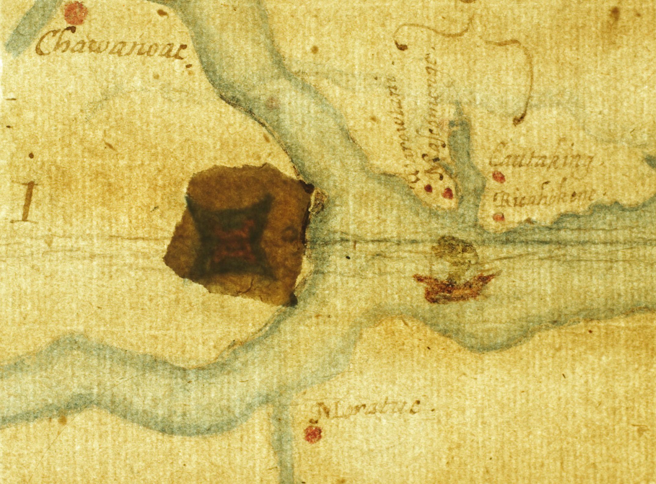
The other Roanoke fort is under a piece of paper. On John White’s La Virginea Pars, a patch covers a place at the western end of Albemarle Sound. In transmitted light, British Museum researchers found a four-pointed fortification symbol beneath it and a faint related symbol on top. The spot is on the mainland, well away from the earthwork a visitor sees on Roanoke Island. English-period finds in the area have kept a possible inland settlement in play. The symbol could mark a proposed strongpoint, a site known to the mapmaker, or a change in what he meant the map to disclose. To establish a built fort there would take evidence on the scale of the moat at Joara or the features at Santa Elena.


A map could travel where the people on it could not. In September 1608 Pedro de Zúñiga, the Spanish ambassador in London, sent Philip III a copy of a chart attributed to John Smith. It showed Jamestown’s triangular fort and scores of Native villages. One annotation reported four clothed men from Roanoke at a place named Ocanahowan. Whether the report was true, someone in the English enterprise thought it worth putting on a map, and a Spanish diplomat thought the map worth copying. England also brought people from the Mediterranean into the story. Drake had liberated captives described as Turks and Moors during his 1585–86 expedition and reached Roanoke before returning to England. The unresolved question is what happened to the different groups of captives. A place on a voyage’s itinerary supplies a lead; a landing or a life ashore needs a record of its own.
Fort Caroline shows how far a name can get ahead of the archaeology. The French built it in 1564, and Spain took it the following year. Its exact site has yet to be securely identified. The memorial on the St. Johns and the proposed site on Georgia’s Altamaha represent different claims about where to look. Farther north, historians once put a French stone castle of about 1540 on the island where the Dutch later built Fort Nassau. The story came with a footprint and a moat, precise enough to sound like a survey. Its early French predecessor remains unsubstantiated. Meanwhile, the documented Dutch successor, Fort Orange, lay under Albany until a crew excavated it ahead of Interstate 787 in 1970 and 1971. A site can disappear from the street and still be exactly where the records say it was.
The Dutch West India Company established Fort Orange in 1624 as a fortified trading station on a Hudson already traveled and traded on by Native people. The company could make treaties, maintain troops and administer settlements. It needed Native suppliers and negotiators to keep the fur trade moving. The corporation’s powers were extensive, but it still mattered who arrived at the dock, who brought pelts, and who could take them elsewhere. The Dutch post gives us a way to read what Louis XIV offered a financier named Antoine Crozat almost a century later.
Crozat’s 1712 grant gave him fifteen years of exclusive trade in French Louisiana along with extensive privileges in mining and other enterprises. The king’s document called the Mississippi the Saint-Louis, the Missouri the Saint-Philippe and the Ouabache the Saint-Jérôme. It described a grant in terms of ports, rivers and the country whose waters fed them. On Herman Moll’s English map of the patent, the boundaries of French claims sit alongside the names of rivers that European geographers were still working out. Some early maps gave the Ouabache name to waters that modern maps distinguish as the lower Ohio. The choice of a map matters if you want to know how much country a reader in 1712 would have thought the patent covered. The harder measure of Crozat’s power was whether his people could actually get a cargo through it.

Antoine Laumet, who made his career under the name de Lamothe Cadillac, had founded Fort Pontchartrain at Detroit in 1701. In 1713 he reached Louisiana to govern under the Crozat arrangement. He brought the experience of a post where traders and officials depended on alliances across the Great Lakes. That September he sent the Quebec-born Louis Juchereau de Saint-Denis out from Mobile in response to a letter from the Spanish missionary Francisco Hidalgo. The expedition carried merchandise and sought access to horses, cattle and markets. At San Juan Bautista the Spanish detained Saint-Denis. He married Manuela Sánchez Navarro, a member of the commandant’s family, and took part in a Spanish expedition establishing missions and a presidio in East Texas. He later commanded at Natchitoches on the French side. The same career makes sense in two sets of colonial records because the trade and family relations crossed the line the officials were trying to hold.
Louis XIV and Philip V were grandfather and grandson. By the time of the Crozat grant, the thrones of France and Spain were both Bourbon. Their agents in North America still seized goods, disputed boundaries and made bargains that Madrid and Paris had little ability to supervise in real time. Saint-Denis could trade through the quarrel. Crozat could not make enough of the larger undertaking and gave up his concession in 1717. John Law’s Company of the West took over the Louisiana enterprise. In 1723, under the succeeding company regime, work began on masonry Fort Condé at Mobile. The plans are French, in the engineering tradition associated with Vauban. Most of the people who built the fort were enslaved men brought from West Africa.
Were Muslims among the people who laid Fort Condé’s masonry? A slave ship’s port of embarkation, an origin label in a census, and evidence of someone’s religion answer different questions. A promising way into the archive would be to match the ships and company work parties of the 1720s to Mobile inventories and parish records. On the Georgia coast there is a direct record of a Muslim life. Bilali Muhammad, held in slavery on Sapelo Island, wrote in Arabic on Islamic law and practice. A later account associates him and other armed men with the defense of the island during the War of 1812. His manuscript survives at the University of Georgia. It shows what evidence about a particular person’s religion can look like, and how much of that person a colonial labor record would leave out.

In the interior, the waterways France wrote into patents were much older than France’s claims to them. At Cahokia, near present-day St. Louis, beakers dating from about 1050 to 1250 preserve chemical traces of holly used in a caffeinated ritual drink. The plants grew far to the south of Cahokia. The material had reached the Mississippi Valley long before a French charter named the river. Centuries later Louis Jolliet saw the advantage of cutting across the divide between the Chicago and Illinois waters. At Kekionga, the equivalent problem was already being solved by Myaamia people who knew when and where to move a load between the Maumee and the Wabash. Forts could guard a portage. Somebody still had to know how to get a boat and its cargo across.


France established Ouiatenon on the Wabash in 1717 as a post of Canada. Downriver, Vincennes belonged to the Louisiana side of French administration. Between and around the posts were communities of Wea, Miami and Piankashaw people with their own interests in the trade. The fort at Ouiatenon was a post within that country, and the blockhouse a visitor sees today is a reconstruction near the archaeological site. At the Maumee–Wabash carry, Tacumwah and her son Jean Baptiste Richardville ran a carrying business. Her brother Pacanne later took a small party to Spanish Louisiana and lived for a time in the Ouachita district while Richardville exercised leadership at Kekionga. Cadillac and Saint-Denis make the French connection legible in official records. Tacumwah’s family makes it possible to follow the same continent from the people who furnished the transport and could move across jurisdictions themselves.


Britain found out how much those local relationships mattered when France ceded the Illinois country. Fort de Chartres was supposed to pass to the British after the peace of 1763. An attempt to reach it by the lower Mississippi failed. George Croghan was sent west from Fort Pitt to negotiate passage for a garrison. Taken prisoner on the way, he was brought to Ouiatenon, where he negotiated with people the British needed to let them through. In October 1765 Captain Thomas Stirling reached Fort de Chartres with troops from Fort Pitt and received the post. Two years had elapsed between the treaty that awarded the country and the arrival of men who could raise the flag there.


Britain inherited French posts and employed the same routes. In 1778, when George Rogers Clark took Kaskaskia and the British learned what was happening at Vincennes, Henry Hamilton came out of Detroit, along Lake Erie, up the Maumee, across the carry and down the Wabash. His journal records the stops and decisions of the expedition. In Detroit, Fort Lernoult was built in the winter of 1778–79. The French Fort Pontchartrain and British Fort Lernoult occupied different sites in the town. The British also brought a kind of association that moved with the garrison. A Detroit lodge was warranted in 1764, and by 1772 two Irish military lodges of the 10th Regiment were working there. The warrants give a documented way to follow men between forts. If membership rolls can be matched to traders’ names in invoices and contracts, we may be able to see whether the lodge also helped men do business across garrison lines.
While Britain held Detroit, Spain was making its own claim to the middle of the continent. In March 1780 Bernardo de Gálvez took British Fort Charlotte at Mobile, the former Fort Condé. In May a force organized from Michilimackinac attacked Spanish St. Louis, where the small stone tower of Fort San Carlos was the principal defensive work. The following winter a Spanish-led party from St. Louis struck Fort St. Joseph at present-day Niles, Michigan, briefly raised Spanish colors and asserted a claim to the post and river. Spain’s hold at Mobile had a garrison behind it. Its occupation of Fort St. Joseph was brief, but it gave Spanish diplomats a claim to invoke in the wider argument over the Northwest. At St. Louis the marker for San Carlos now stands by the city blocks that grew over its defenses. The stone tower, the Gulf fort and the Michigan outpost belonged to the same wartime contest.
In March 1794, Henry Knox wrote confidential instructions to Anthony Wayne about an abandoned French fort on the lower Ohio. He wanted Wayne to send a detachment to Fort Massac, build a redoubt and a blockhouse, and send cannon from Fort Washington. If armed parties came downriver intending to invade Spanish territory, the fort’s commander was to warn them and use military force if they persisted. The people Knox expected him to stop were Americans. Clark, who had passed the same site in 1778 on his way to take Kaskaskia for Virginia, had accepted a French commission and was trying to raise an expedition against Spanish Louisiana. One commission he issued in 1794 identifies him as commander of the French Revolutionary Legion of the Mississippi. His expedition foundered. The United States rebuilt the fort. A customs port and post office later operated at the site.


In the same year the British, with the support of the Indigenous confederacy resisting the U.S. advance, built Fort Miamis on the lower Maumee. After Fallen Timbers, Wayne’s army built the first American Fort Wayne at Kekionga, near the other end of the Maumee system. In the south, Spain built Fort Confederation on the site of the old French Fort Tombecbe. Choctaw leaders had agreed to set aside ground for the post, where the Spanish would provide supplies. The French had used a palisade with a roughly three-pointed outline. Spain put up a smaller earthwork. It was building for an alliance it needed to hold, on ground it had to negotiate for, while the United States tried to stop an unauthorized war farther up the river system.
The Canadian-born John Francis Hamtramck had commanded at Vincennes, where the first Fort Knox dated to 1787. He took command of the new post at Kekionga and in 1796 took over Fort Lernoult when Britain finally yielded Detroit to the United States. In that interval, the Treaty of Greenville specified a six-mile square at Fort Wayne and a separate two-mile square at the Wabash end of the portage. It spelled out passage across the carry and down the Wabash to the Ohio. The same article described land around the British fort on the lower Maumee even though Britain still held the post. Two months later, in Pinckney’s Treaty, Spain agreed to let Americans store export goods in New Orleans. Between those two agreements, the republic secured access to a Native-controlled portage and space in a Spanish port. A boat coming down the western rivers needed both kinds of permission.
Spain kept Mobile after the treaty. The Panton, Leslie firm, run by Scots with connections to the British Atlantic, kept stores at Mobile and elsewhere under Spanish permission and enjoyed a near monopoly on much of the Southeastern Native trade. Alexander McGillivray, the Creek leader, had a business interest in the firm. The store and the fort could be run by people with very different allegiances. James Wilkinson supplies the more famous instance. He raided the Miami town of Kenapacomaqua on the Eel River near present-day Logansport in 1791 and was secretly in Spain’s pay during his American military career. In 1813 he was the U.S. general who took the surrender of Spain’s Fuerte Carlota at Mobile. The city passed to the United States by capitulation. The man who accepted it had spent years navigating obligations to both powers.
The young republic soon had its own stores, known as factories. The federal trading house at Fort Wayne began in the early 1800s under John Johnston. He took in pelts for shipment east, helped provision the garrison and distributed payments for land cessions. His surviving book of invoices and inventories begins in pounds, shillings and pence and later changes to dollars and cents. On the Tombigbee, at St. Stephens, the same program put an American storekeeper into an old Spanish blockhouse. A former Spanish warehouse at the site was subsequently used as a land office and a post office. At both places you can follow the transfer of power through what happened inside a room.
Jefferson laid out one purpose of the trading houses in a private letter to William Henry Harrison in 1803. He wanted the government stores to sell cheaply enough to beat private competitors. If influential Native customers took on debts beyond their ability to pay, he expected land cessions to settle them. The letter gives the policy. To find out how it played out, match the people in Johnston’s book to the annuity lists and land transactions. A sale, a treaty payment and a private debt each left a different record. On the Wabash, a further step would be to read those accounts alongside what Myaamia families were doing to keep land and political authority.
At the same time, France was trying to recover the Louisiana it had given up. In 1796, the French minister in the United States sent General Victor Collot west to gather military, political and commercial intelligence. Collot drew the Spanish fort at New Madrid with part of the work already washed away by the Mississippi. The Spanish arrested him and expelled him. The atlas that eventually came out of his mission preserves a fort at the moment it was being lost to the river. It also shows what a French officer wanted to know about the country before any change of flag.
In 1800 Spain agreed at San Ildefonso to return Louisiana to France. The treaty described the province partly by the extent it had held when France possessed it, leaving room for argument about the older boundaries. Napoleon instructed his naval minister to prepare an expedition to take possession under cover of an apparent destination in Santo Domingo. How much the planners drew on Collot’s intelligence is a question for the instructions and working maps. The Louisiana Purchase intervened. Spain still held Mobile, and the United States needed another decade and Wilkinson’s expedition to take it.
The strongest Napoleon connection to the forts came after his fall. His former aide Simon Bernard entered American service and in 1817 produced a plan for the fort at Mobile Point that became Fort Morgan. The position was near Fort Bowyer, the earlier work at the entrance to the bay. Bernard’s design joined Vauban-style bastions to casemates in the tradition of Montalembert. He and Joseph Totten also surveyed the Ohio and Mississippi for navigation improvements, studying sandbars and submerged timber that could wreck a boat. In 1850 Montgomery Meigs drew alterations for the barracks at Detroit’s Fort Wayne under Totten’s direction. For Bernard and Totten, keeping a river open for traffic and securing its approaches were both Army engineering work.


Another officer from Napoleon’s army came to the Mobile river system for a different reason. Charles Lefebvre-Desnouettes had commanded the mounted chasseurs of the Imperial Guard, the regiment to which Napoleon’s Mamluk company was attached. After the empire fell, he became one of the founders of the Vine and Olive Colony near present-day Demopolis on the Tombigbee. The group had organizers with ties to Santo Domingo, sent scouts into the Ohio Valley and eventually received a congressional land grant in Alabama. In Bernard’s plans and Lefebvre-Desnouettes’s colony, two people from the same defeated empire came into the river country through different doors. One was hired to plan its defenses. The other came with a company of exiles looking for land.
Britain tried a different experiment on the Gulf during the War of 1812. Its officers built a fort at Prospect Bluff on the Apalachicola, within Spanish Florida. They left arms and the fort to their Black allies when they withdrew in 1815. People who had escaped slavery lived in and around the post, and a Spanish official sent to recover fugitives feared it would become a permanently independent settlement. U.S. forces destroyed the fort in 1816. The plan for Fort Gadsden shows the new American work going up in 1818 within the bounds of the old one. In Mobile, a colonial company had used enslaved labor to build a fort for itself. At Prospect Bluff, people who had escaped slavery held a fort and used it to defend their own freedom. The American builders found a site that already had a name, inhabitants and a political history.
The peace after the War of 1812 also brought people back to the Detroit River. In September 1815, commissioners including William Henry Harrison met representatives of eight Native nations at Springwells. Pacanne made his mark, recorded as “Pacan,” among the Miami signatories. He belonged to the family that had moved goods across the Maumee–Wabash portage, and he had lived in the Spanish Louisiana that American merchants and officers were trying to reach. Springwells had freshwater, a river landing, and a much older use as a burial and ceremonial place. The site had drawn people to the river long before either side could have imagined the terms Harrison brought to the meeting.
Once the Americans began cutting the Wabash and Erie Canal in 1832, the old problem of moving freight between watersheds acquired new contractors and creditors. In New York, DeWitt Clinton had broken ground for the Erie Canal in 1817 and helped inaugurate Ohio’s canal construction in 1825. While he did that he was also Grand Master of the national Knights Templar Grand Encampment. In Indiana, Governor James Whitcomb’s administration negotiated the deal that put the Wabash and Erie Canal in a bondholders’ trust in 1847. The following year the state’s first Templar commandery was organized at his residence. Two of the four bodies that later formed Indiana’s Grand Commandery were at Lafayette and Fort Wayne, both canal towns. The next thing to look for is overlap among the actual men who signed canal contracts, sat on boards and appeared in commandery registers. The ceremonies and the charter dates give places and names to start with.
The new Fort Wayne at Detroit came out of a different use of lodge organization. The Patriot War of the late 1830s drew men on the American side into secret Hunters’ Lodges that supported armed incursions into British Canada. The United States had once put cannon at Massac to stop a private expedition heading south. Now it had to contend with private expeditions heading north. The Hunters gave their ranks names such as Snowshoe and Beaver, borrowed from the work and travel of the northern country. Congress authorized a new fort near Detroit in 1841 amid the border troubles, and the Army acquired land at Springwells in 1842. It built a four-bastioned fort on the river below the sites of both French Fort Pontchartrain and British Fort Lernoult. By the local fort’s account, a central burial mound was destroyed and its earth went into construction. Meigs, the officer overseeing the work, would later help establish Arlington National Cemetery on the estate that had been home to Robert E. Lee.


In 1842 the Webster–Ashburton Treaty also settled a problem that an earlier map had written into the border. The 1783 Treaty of Paris sent the line north of Isle Royale and an island named Phelipeaux. Surveyors found that the second island did not exist. Its name came from the same French ministerial family whose Pontchartrain title remained attached to Detroit’s first fort and a lake in Louisiana. At Albemarle Sound, a paper patch obscured a place where someone had put a fort symbol. At Lake Superior, the name of an imaginary island made it into a binding description of national territory. The border commission had to go back to the water and find a line a surveyor could mark.

On the Pacific, the Russian-American Company left a parallel pair of records. It founded Fort Ross in 1812 on the California coast, within Spanish claims and in Kashaya country. Russian officials drew up a document after meeting Kashaya Pomo and Bodega Miwok leaders in 1817. Only the Russian officials signed the surviving record. When the company sold its assets to John Sutter in 1841, the account priced the structures and chattels. Livestock, equipment and some buildings were sent away to Sutter’s operation. Read the two papers together and you can see the questions one signature could leave for the next generation. The company could sell a building, a boat or a herd. What it had acquired from the people who lived there had been recorded in a different kind of transaction, by one side.


In Mobile the last transfer was to a highway. The city had dismantled Fort Condé in the nineteenth century. Work on the Wallace Tunnel exposed remnants in 1966, and a scaled reconstruction opened for the bicentennial in 1976. Fort Orange had come back into view a few years earlier ahead of another interstate project. In both cities, a new way to move people and goods cut across the remains of an older one. In Mobile the French plan still gives the full dimensions. Above the tunnel, the reconstructed walls give a visitor a portion of the fort at four-fifths scale. Part of the old work can be seen nearby in Mardi Gras Park. To walk from the replica to those remnants is to see the difference between what the city chose to put back and what the road builders found.

